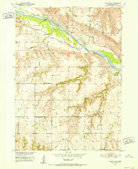
1950 Map of Pishelville
USGS Topo · Published 1952About this map
The Niobrara River creates a braided waterway and broad valley as it winds through this portion of Knox County. Along its southern banks, the small settlement of Pishelville sits near the mouth of Pishel Creek, while Pishelville Island splits the river's flow just downstream. The landscape is defined by the transition from the river bottom to higher ground marked by landmarks such as Stony Butte, where the rural topography is dotted with family and community anchors of the early 1950s.
Find a feature on this map
21 named features on this map. Tap any name to fly to it.
Don’t see what you’re looking for? This feature index may not catch every label — zoom into the map to look around manually.
Map Details
Editions of this 1950 Pishelville Map
2 editions found
Other maps of this area

1950 · Niobrara
USGS Topo · 1:24,000

1950 · Verdel
USGS Topo · 1:24,000

1950 · Verdigre NE
USGS Topo · 1:24,000

1950 · Pishelville
USGS Topo · 1:24,000

1950 · Monowi
USGS Topo · 1:24,000

1952 · Monowi
USGS Topo · 1:24,000

1952 · Dorsey
USGS Topo · 1:24,000

1954 · Walnut
USGS Topo · 1:24,000

1954 · Verdigre
USGS Topo · 1:24,000

1954 · Star
USGS Topo · 1:24,000