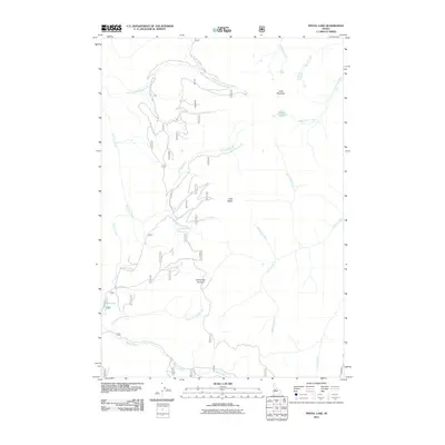
2011 Map of Pistol Lake
USGS Topo · Published 2011About this map
Pistol Lake and the high ridgelines of Valley County define this backcountry landscape, where drainage patterns shape the network of forest access roads. The terrain is marked by prominent elevations such as Lake Mountain and Little Baldy, with Snowshoe Summit serving as a primary navigational point between the watersheds. A dense web of waterways, including Burntlog Creek, Boomerang Creek, and Peanut Creek, feeds into the larger Pistol Creek and Sand Creek systems.
Find a feature on this map
43 named features on this map. Tap any name to fly to it.
Don’t see what you’re looking for? This feature index may not catch every label — zoom into the map to look around manually.
Map Details
Editions of this 2011 Pistol Lake Map
This is the sole edition of this map. No revisions or reprints were ever made.
Other maps of this area

1937 · Yellow Pine
USGS Topo · 1:48,000

1943 · Yellow Pine
USGS Topo · 1:62,500

1954 · Warm Lake
USGS Topo · 1:62,500

1957 · Challis
USGS Topo · 1:250,000

1960 · Challis
USGS Topo · 1:250,000

1961 · Chinook Mtn
USGS Topo · 1:62,500

1963 · Challis
USGS Topo · 1:250,000
1973 · Big Chief Creek
USGS Topo · 1:24,000
1973 · Chilcoot Peak
USGS Topo · 1:24,000
1973 · Log Mountain
USGS Topo · 1:24,000