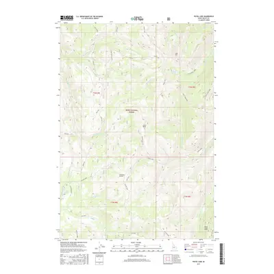
2017 Map of Pistol Lake
USGS Topo · Published 2017About this map
Pistol Lake and the surrounding high-elevation drainages of the Boise National Forest dominate this mid-century landscape in Valley County. The terrain is defined by a dense network of mountain streams, including the north-flowing E Fork Burntlog Creek and Forty-Four Creek, which carve through the steep topography between Lake Mtn and Little Baldy. Navigation through this backcountry is represented by the north-south Summit Trail and the McClure route, which provide access across several prominent divides.
Find a feature on this map
36 named features on this map. Tap any name to fly to it.
Don’t see what you’re looking for? This feature index may not catch every label — zoom into the map to look around manually.
Map Details
Editions of this 2017 Pistol Lake Map
This is the sole edition of this map. No revisions or reprints were ever made.
Other maps of this area

1937 · Yellow Pine
USGS Topo · 1:48,000

1943 · Yellow Pine
USGS Topo · 1:62,500

1954 · Warm Lake
USGS Topo · 1:62,500

1957 · Challis
USGS Topo · 1:250,000

1960 · Challis
USGS Topo · 1:250,000

1961 · Chinook Mtn
USGS Topo · 1:62,500

1963 · Challis
USGS Topo · 1:250,000
1973 · Big Chief Creek
USGS Topo · 1:24,000
1973 · Chilcoot Peak
USGS Topo · 1:24,000
1973 · Log Mountain
USGS Topo · 1:24,000