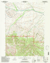
1991 Map of Pitchfork
USGS Topo · Published 1997About this map
Pitchfork sits at the northern edge of this Park County landscape, where the Greybull River cuts a wide valley through high-altitude terrain. The map documents an area defined by the management of water and resources, evidenced by the Pitchfork Ditch and the Sunshine Supply Ditch which trace the contours of the river valley. To the south, the landscape rises into the Shoshone National Forest, a region marked by steep drainages including Francs Creek, Gwinn Fork, and Pappapa Creek. Industrial activity is concentrated in the west at the Four Bear Oil Field, where numerous tanks and drill holes are noted. The Timber Creek Ranger Station serves as a lone administrative outpost at the forest boundary, illustrating the transition from the worked valley floor to the protected wilderness of the mountains.
Find a feature on this map
28 named features on this map. Tap any name to fly to it.
Don’t see what you’re looking for? This feature index may not catch every label — zoom into the map to look around manually.
Map Details
Editions of this 1991 Pitchfork Map
This is the sole edition of this map. No revisions or reprints were ever made.
Other maps of this area

1904 · Kirwin
USGS Topo · 1:125,000

1906 · Kirwin
USGS Topo · 1:125,000

1955 · Cody
USGS Topo · 1:250,000

1955 · Thermopolis
USGS Topo · 1:250,000

1957 · Irish Rock
USGS Topo · 1:62,500

1957 · Sunshine Reservoir
USGS Topo · 1:62,500

1958 · Cody
USGS Topo · 1:250,000

1958 · Thermopolis
USGS Topo · 1:250,000

1962 · Thermopolis
USGS Topo · 1:250,000

1962 · Cody
USGS Topo · 1:250,000