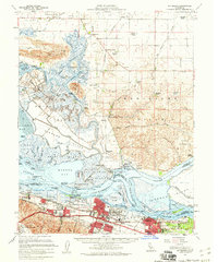
1953 Map of Pittsburg
USGS Topo · Published 1960About this map
Industrial expansion and marshland navigation define this 1950s study of the Delta, where the Sacramento River and San Joaquin River converge. The urban centers of Pittsburg and Antioch are shown during a period of heavy development, featuring an oil refinery, filtration plant, and the sprawling Ambrose district. This era reflects the vital role of rail transport, with the Atchison, Topeka, and Santa Fe lines serving the industrial waterfront.
Find a feature on this map
120 named features on this map. Tap any name to fly to it.
Don’t see what you’re looking for? This feature index may not catch every label — zoom into the map to look around manually.
Map Details
Editions of this 1953 Pittsburg Map
2 editions found
Other maps of this area

1896 · Carquinez Strait
USGS Topo · 1:62,500

1896 · Mt. Diablo
USGS Topo · 1:62,500

1897 · Concord
USGS Topo · 1:62,500

1898 · Karquines
USGS Topo · 1:62,500

1898 · Mt. Diablo
USGS Topo · 1:62,500

1901 · Karquines
USGS Topo · 1:62,500

1902 · Napa
USGS Topo · 1:125,000

1907 · Antioch
USGS Topo · 1:62,500

1908 · Vacaville
USGS Topo · 1:62,500

1908 · Courtland
USGS Topo · 1:62,500