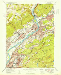
1949 Map of Pittston
USGS Topo · Published 1949About this map
The Susquehanna River and Lackawanna River converge at the heart of this post-war landscape, marking a vital industrial corridor through Luzerne County. The extensive infrastructure of the Lehigh Valley and Central RR of New Jersey lines, including the sprawling Coxton Yards, highlights the era's reliance on rail transport for the region's coal and manufacturing output. Settlements like West Pittston, Duryea, and Pittston appear densely developed, punctuated by local landmarks such as the Wyoming Monument and several schools including Memorial High Sch.
Find a feature on this map
90 named features on this map. Tap any name to fly to it.
Don’t see what you’re looking for? This feature index may not catch every label — zoom into the map to look around manually.
Map Details
Editions of this 1949 Pittston Map
2 editions found
Other maps of this area

1889 · Scranton
USGS Topo · 1:62,500

1891 · Wilkesbarre
USGS Topo · 1:62,500

1891 · Scranton
USGS Topo · 1:62,500

1893 · Pittston
USGS Topo · 1:62,500

1893 · Scranton
USGS Topo · 1:62,500

1894 · Wilkesbarre
USGS Topo · 1:62,500

1922 · Stoddartsville
USGS Topo · 1:62,500

1924 · Stoddartsville
USGS Topo · 1:62,500

1943 · Scranton
USGS Topo · 1:125,000

1943 · Stoddartsville
USGS Topo · 1:62,500