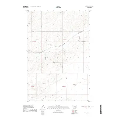
2020 Map of Pizarro
USGS Topo · Published 2020About this map
Pizarro sits as a central focal point in this portion of Adams County, where the high desert landscape is defined by the sharp relief of McElroy Coulee and the broad expanse of Rattlesnake Flat. The geographic layout is dominated by a systematic grid of section-line roads, many of which carry the names of local families such as Dewald Rd, Bauer Rd, and Theil Rd, providing a clear record of land ownership patterns in this agricultural region. A significant modern feature of the landscape is the Palouse To Cascades State Park Trail, which follows an east-west trajectory through the center of the quadrangle. This trail occupies a former rail corridor, tracing the historical movement of goods and people across the Columbia Basin. The intersection of this path with arterial routes like E Lind Ralston Rd and Paha Packard Rd highlights the area's transition from an active railroad economy to one focused on recreation and rural transport.
Find a feature on this map
25 named features on this map. Tap any name to fly to it.
Don’t see what you’re looking for? This feature index may not catch every label — zoom into the map to look around manually.
Map Details
Editions of this 2020 Pizarro Map
This is the sole edition of this map. No revisions or reprints were ever made.
Other maps of this area

1916 · Connell
USGS Topo · 1:125,000

1918 · Connell
USGS Topo · 1:125,000

1923 · Washtucna
USGS Topo · 1:62,500

1925 · Washtucna
USGS Topo · 1:62,500

1953 · Walla Walla
USGS Topo · 1:250,000

1953 · Ritzville
USGS Topo · 1:250,000

1958 · Walla Walla
USGS Topo · 1:250,000

1959 · Ritzville
USGS Topo · 1:250,000

1965 · Ritzville
USGS Topo · 1:250,000

1967 · Ritzville SW
USGS Topo · 1:24,000