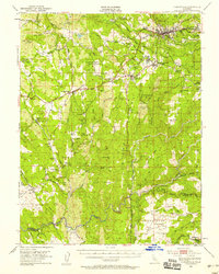
1949 Map of Placerville
USGS Topo · Published 1958About this map
Placerville and the surrounding gold country of the western Sierra foothills appear here during the late 1940s, a period when the region's deep mining heritage still defined its landscape. The map captures an intricate network of hard-rock mines and prospects, such as the Sugarloaf Mine and Vandalia Mine, scattered among family-named settlements like Kingsville and Smiths Flat. In the southern reaches, the Shenandoah Valley reveals a rural agricultural pattern, anchored by the Shenandoah Sch and Shenandoah Cem. Cultural history is evident in the inclusion of the Shingle Springs Indian Reservation and several distinct burial grounds, including a Chinese Cemetery near Logtown. The Southern Pacific railroad corridor winds through the center, connecting established hubs like Diamond Springs and Shingle Springs to the wider California economy, while a network of siphons and canals suggests the critical role of water management in this mineral-rich terrain.
Find a feature on this map
105 named features on this map. Tap any name to fly to it.
Don’t see what you’re looking for? This feature index may not catch every label — zoom into the map to look around manually.
Map Details
Editions of this 1949 Placerville Map
5 editions found

Other maps of this area

1889 · Jackson
USGS Topo · 1:125,000

1891 · Sacramento
USGS Topo · 1:125,000

1891 · Placerville
USGS Topo · 1:125,000

1892 · Jackson
USGS Topo · 1:125,000

1892 · Sacramento
USGS Topo · 1:125,000

1892 · Placerville
USGS Topo · 1:125,000

1893 · Placerville
USGS Topo · 1:125,000

1893 · Sacramento
USGS Topo · 1:125,000

1894 · Lodi
USGS Topo · 1:125,000

1897 · Jackson
USGS Topo · 1:125,000