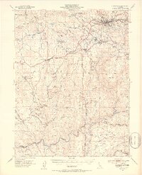
1949 Map of Placerville
USGS Topo · Published 1953About this map
The gold country of El Dorado County is charted here as the mid-century landscape transitioned from its mining roots toward modern infrastructure. Placerville serves as the hub, with the Placerville Airport and the Southern Pacific rail line connecting the Mother Lode to the valley. A dense network of mineral claims and operations including the Funny Bug Mine, Starlight Mine, and Big Canyon Mine are spread across the foothills, underscoring the era's persistent industrial character.
Find a feature on this map
109 named features on this map. Tap any name to fly to it.
Don’t see what you’re looking for? This feature index may not catch every label — zoom into the map to look around manually.
Map Details
Editions of this 1949 Placerville Map
5 editions found

Other maps of this area

1889 · Jackson
USGS Topo · 1:125,000

1891 · Sacramento
USGS Topo · 1:125,000

1891 · Placerville
USGS Topo · 1:125,000

1892 · Jackson
USGS Topo · 1:125,000

1892 · Sacramento
USGS Topo · 1:125,000

1892 · Placerville
USGS Topo · 1:125,000

1893 · Placerville
USGS Topo · 1:125,000

1893 · Sacramento
USGS Topo · 1:125,000

1894 · Lodi
USGS Topo · 1:125,000

1897 · Jackson
USGS Topo · 1:125,000