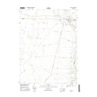
2016 Map of Plain City
USGS Topo · Published 2016About this map
Plain City sits at the junction of the Union and Madison county lines, serving as a historic hub where the Big Darby Creek and Sugar Run converge. This 2016 survey illustrates the intricate network of agricultural drainage that defines the surrounding landscape, including the Worthington Ditch, Eli Jones Ditch, and Yutzy Ditch. These waterways underscore the region's long-standing commitment to land reclamation for farming, a practice that has shaped the central Ohio terrain for generations. For local historians and genealogists, the map is particularly rich in cemetery data, documenting numerous family and township burial grounds scattered across the countryside. From the centrally located Darby Township Cemetery to the more outlying Converse-Huff Cemetery and Smith Cemetery, the distribution of these sites reflects the early settlement patterns and family farmsteads established near the small village of Amity.
Find a feature on this map
81 named features on this map. Tap any name to fly to it.
Don’t see what you’re looking for? This feature index may not catch every label — zoom into the map to look around manually.
Map Details
Editions of this 2016 Plain City Map
This is the sole edition of this map. No revisions or reprints were ever made.
Other maps of this area

1901 · Dublin
USGS Topo · 1:62,500

1903 · Dublin
USGS Topo · 1:62,500

1907 · London
USGS Topo · 1:62,500

1916 · Milford Center
USGS Topo · 1:62,500

1923 · West Columbus
USGS Topo · 1:62,500

1925 · West Columbus
USGS Topo · 1:62,500

1944 · Milford Center
USGS Topo · 1:62,500

1947 · Columbus
USGS Topo · 1:250,000

1950 · Marion
USGS Topo · 1:250,000
1954 · Shawnee Hills
USGS Topo · 1:24,000