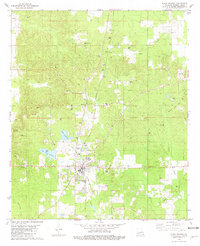
1981 Map of Plain Dealing
USGS Topo · Published 1981About this map
Plain Dealing anchors the southern portion of this northern Louisiana landscape, where the local economy in the early 1980s is defined by a dense network of resource extraction and rural community centers. The St Louis Southwestern railroad runs through the heart of the settlement, passing near Antrim and Bolinger. This era shows significant industrial activity throughout the parish, marked by numerous Oil Wells, Gravel Pits, and a Sandpit, particularly near the Redland and Gas Field. Rural life is centered around local congregations and family landmarks, including Israelite Ch, Union Chapel, and the Caldwell Cem. Water features such as Lake Plain Dealing, Lake Dogwood, and Cypress Bayou provide a contrast to the industrial footprint of the timber and energy sectors.
Find a feature on this map
43 named features on this map. Tap any name to fly to it.
Don’t see what you’re looking for? This feature index may not catch every label — zoom into the map to look around manually.
Map Details
Editions of this 1981 Plain Dealing Map
This is the sole edition of this map. No revisions or reprints were ever made.
Other maps of this area

1932 · Hosston NE
USGS Topo · 1:31,680

1932 · Hosston SE
USGS Topo · 1:31,680

1948 · Vivian
USGS Topo · 1:62,500

1950 · Plain Dealing SW
USGS Topo · 1:31,680

1950 · Plain Dealing NE
USGS Topo · 1:31,680

1950 · Plain Dealing SE
USGS Topo · 1:31,680

1950 · Plain Dealing NW
USGS Topo · 1:31,680

1952 · Doddridge SE
USGS Topo · 1:24,000

1952 · Bradley
USGS Topo · 1:24,000

1952 · Bradley SE
USGS Topo · 1:24,000