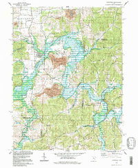
1994 Map of Plainfield
USGS Topo · Published 1998About this map
Wills Creek Lake and the serpentine course of Wills Creek dominate this landscape, illustrating the complex hydrology where the borders of Coshocton, Guernsey, and Muskingum counties meet. The presence of several Strip Mines north of Linton Mills reveals the industrial coal-mining history that reshaped the terrain, while the broader rural character is maintained by small clusters of activity at Plainfield and Birds Run. This late 20th-century view captures a transition in local infrastructure, featuring the Tri-City Airport in the northwest and an extensive network of rural routes like Standing Rock Road. Genealogists will find a high density of burial grounds throughout the townships, including Plainfield Cem, Union Hill Cem, and Schweitzer Cem, which anchor the area's legacy of family farms and dispersed settlements.
Find a feature on this map
46 named features on this map. Tap any name to fly to it.
Don’t see what you’re looking for? This feature index may not catch every label — zoom into the map to look around manually.
Map Details
Editions of this 1994 Plainfield Map
This is the sole edition of this map. No revisions or reprints were ever made.
Other maps of this area

1908 · Conesville
USGS Topo · 1:62,500

1909 · Cambridge
USGS Topo · 1:62,500

1910 · Conesville
USGS Topo · 1:62,500

1911 · Newcomerstown
USGS Topo · 1:62,500

1912 · Cambridge
USGS Topo · 1:62,500

1913 · Newcomerstown
USGS Topo · 1:62,500

1913 · Coshocton
USGS Topo · 1:62,500

1915 · Coshocton
USGS Topo · 1:62,500

1943 · Coshocton
USGS Topo · 1:62,500

1943 · Newcomerstown
USGS Topo · 1:62,500