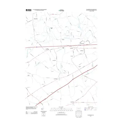
2013 Map of Plainfield
USGS Topo · Published 2013About this map
The winding Conodoguinet Cr defines the northern landscape of this Cumberland County region, where legacy milling sites like Keiters Mill and Elliotts Mill sit along the creek's banks. This area of West Pennsboro Township is a mosaic of agriculture and small crossroads settlements, including Blosserville, Greason, and Bears Crossroads. The natural hydrology of the Great Valley is on full display here, characterized by significant karst features such as Mount Rock Spring and Alexander Spring, which feed their respective runs. To the north, Opossum Lake provides a major water feature among the rolling fields. The map also records local recreational and transportation landmarks like the Cumberland Golf Course and the small landing strip at Heberlig Airport, showing the township's transition into the early 21st century while maintaining its rural character and historic place-names.
Find a feature on this map
102 named features on this map. Tap any name to fly to it.
Don’t see what you’re looking for? This feature index may not catch every label — zoom into the map to look around manually.
Map Details
Editions of this 2013 Plainfield Map
This is the sole edition of this map. No revisions or reprints were ever made.
Other maps of this area

1904 · Carlisle
USGS Topo · 1:62,500

1907 · New Bloomfield
USGS Topo · 1:62,500

1919 · Newville
USGS Topo · 1:62,500

1930 · Loysville
USGS Topo · 1:62,500

1933 · Loysville
USGS Topo · 1:62,500

1943 · New Bloomfield
USGS Topo · 1:62,500

1943 · Carlisle
USGS Topo · 1:62,500

1945 · Newville
USGS Topo · 1:62,500

1950 · Harrisburg
USGS Topo · 1:250,000
1952 · Andersonburg
USGS Topo · 1:24,000
Featured Places
- Plainfield, West Pennsboro Township
- West Pennsboro Township, PA
- Lower Frankford Township, PA
- Bears Crossroads, West Pennsboro Township
- Bloserville, Upper Frankford Township