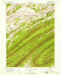
1952 Map of Andersonburg
USGS Topo · Published 1958About this map
Andersonburg and the agricultural valleys of western Perry County are defined by the parallel ridges of Bowers Mountain and Blue Mountain in this mid-century survey. The landscape reflects a transition away from early industrial transport, marked by a dismantled railroad that once shadowed Sherman Creek. Local life at the time centered on a network of rural institutions, including Centre Church and several small schoolhouses like Clarks School and Cisna School. Evidence of earlier history persists at Fort Roberson and scattered family landmarks such as Bernheisel Ridge. The presence of an approximate pipeline and multiple pumping stations indicates the area's role in the regional energy infrastructure of the 1950s, while the rugged terrain of Sheaffer Valley remained largely undeveloped forest.
Find a feature on this map
63 named features on this map. Tap any name to fly to it.
Don’t see what you’re looking for? This feature index may not catch every label — zoom into the map to look around manually.
Map Details
Editions of this 1952 Andersonburg Map
4 editions found
Other maps of this area

1919 · Newville
USGS Topo · 1:62,500

1919 · Mattawana
USGS Topo · 1:62,500

1923 · Shippensburg
USGS Topo · 1:62,500

1930 · Loysville
USGS Topo · 1:62,500

1933 · Loysville
USGS Topo · 1:62,500

1936 · East Waterford
USGS Topo · 1:48,000

1941 · East Waterford
USGS Topo · 1:62,500

1943 · Shippensburg
USGS Topo · 1:62,500

1945 · Newville
USGS Topo · 1:62,500

1945 · Shippensburg
USGS Topo · 1:62,500
Featured Places
- Saville Township, PA
- Centre, Southwest Madison Township
- Fort Robinson, Northeast Madison Township
- Northeast Madison Township, PA
- Andersonburg, Southwest Madison Township