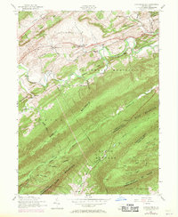
1952 Map of Andersonburg
USGS Topo · Published 1971About this map
Sheaffer Valley and the surrounding ridges of the Appalachian Mountains define this mid-century landscape on the border of Perry and Cumberland Counties. The 1952 data, updated in 1969, shows a rural economy centered on the winding course of Sherman Creek. Small clusters of settlement such as Andersonburg, Cisna Run, and Bixler are connected by a network of backroads and a dismantled railroad that previously served the valley's timber or agricultural needs. The map is particularly valuable for genealogists, as it documents numerous local landmarks including Clarks School, St Paul Church, and the Emory Chapel Cemetery. From the heights of Bowers Mountain to the depths of Doubling Gap, the topography reveals a pattern of ridge-and-valley settlement where churches like Centre Church and isolated cemeteries served widely dispersed farmsteads.
Find a feature on this map
62 named features on this map. Tap any name to fly to it.
Don’t see what you’re looking for? This feature index may not catch every label — zoom into the map to look around manually.
Map Details
Editions of this 1952 Andersonburg Map
4 editions found
Other maps of this area

1919 · Newville
USGS Topo · 1:62,500

1919 · Mattawana
USGS Topo · 1:62,500

1923 · Shippensburg
USGS Topo · 1:62,500

1930 · Loysville
USGS Topo · 1:62,500

1933 · Loysville
USGS Topo · 1:62,500

1936 · East Waterford
USGS Topo · 1:48,000

1941 · East Waterford
USGS Topo · 1:62,500

1943 · Shippensburg
USGS Topo · 1:62,500

1945 · Newville
USGS Topo · 1:62,500

1945 · Shippensburg
USGS Topo · 1:62,500
Featured Places
- Saville Township, PA
- Centre, Southwest Madison Township
- Fort Robinson, Northeast Madison Township
- Northeast Madison Township, PA
- Andersonburg, Southwest Madison Township