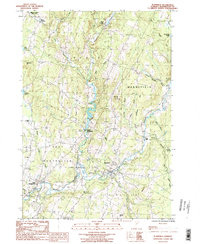
1986 Map of Plainfield
USGS Topo · Published 1987About this map
The Winooski River and its numerous tributaries, including Kingsbury Branch and Beaver Meadow Brook, define the drainage and settlement patterns of this Vermont landscape in the mid-1980s. The village of Plainfield serves as a focal point near the southern map edge, where the river meets Great Brook. To the north, smaller hamlets like Maple Corner and Kents Corners maintain the traditional township structure of Calais and Marshfield.
Find a feature on this map
38 named features on this map. Tap any name to fly to it.
Don’t see what you’re looking for? This feature index may not catch every label — zoom into the map to look around manually.
Map Details
Editions of this 1986 Plainfield Map
This is the sole edition of this map. No revisions or reprints were ever made.
Other maps of this area

1919 · Montpelier
USGS Topo · 1:62,500

1921 · Montpelier
USGS Topo · 1:62,500

1922 · Barre
USGS Topo · 1:48,000

1924 · Barre
USGS Topo · 1:62,500

1939 · Plainfield
USGS Topo · 1:48,000

1940 · Plainfield
USGS Topo · 1:62,500

1943 · Plainfield
USGS Topo · 1:62,500

1944 · Montpelier
USGS Topo · 1:62,500

1947 · Corinth
USGS Topo · 1:62,500

1948 · East Barre
USGS Topo · 1:62,500