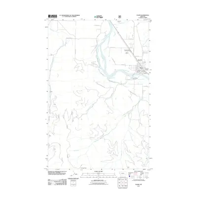
2011 Map of Plains
USGS Topo · Published 2011About this map
The town of Plains sits within a wide bend of the Clark Fork river, serving as a hub for the surrounding ranching and timber country of Sanders County. This 2011 survey illustrates the community's infrastructure, including the Plains Airport and the Plains District Ranger Office, alongside local landmarks like the Sanders County Fairgrounds. The geography is defined by the river's drainage network, fed by Lynch Creek and Combest Creek, while Combest Peak rises as a prominent high point to the south. For those tracing family histories or local development, the map identifies both the Plains Cemetery and the Lynch Cemetery, as well as the Plains-Paradise Rural Fire Dist. The layout of roads like River Rd W and Blackjack Rd shows how the settlement pattern follows the contours of the valley floor and the creek drainages.
Find a feature on this map
38 named features on this map. Tap any name to fly to it.
Don’t see what you’re looking for? This feature index may not catch every label — zoom into the map to look around manually.
Map Details
Editions of this 2011 Plains Map
This is the sole edition of this map. No revisions or reprints were ever made.
Other maps of this area

1918 · St Regis
USGS Topo · 1:125,000

1919 · St. Regis
USGS Topo · 1:125,000

1937 · Thompson Falls
USGS Topo · 1:125,000

1956 · St Regis
USGS Topo · 1:62,500

1956 · Wallace
USGS Topo · 1:250,000

1959 · Plains
USGS Topo · 1:62,500

1960 · Wallace
USGS Topo · 1:250,000
1964 · Big Hole Peak
USGS Topo · 1:24,000

1964 · Baldy Lake
USGS Topo · 1:24,000

1964 · Weeksville
USGS Topo · 1:24,000