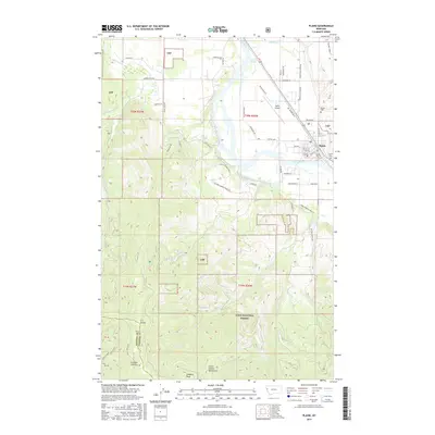
2017 Map of Plains
USGS Topo · Published 2017About this map
The town of Plains occupies a distinctive bend in the Clark Fork river, serving as a valley hub between the high ridgelines of the Coeur d'Alene Mountains. This 2017 study illustrates the intricate interface between residential blocks and the surrounding Lolo National Forest, with the town grid extending toward the Plains Airport. To the south, the landscape rises sharply into the mountains, marked by geographic features like Combest Peak and the C C Divide at the Sanders and Mineral County line. Historical land use is visible in the network of ranch roads and drainages such as Miller Cr and Combest Cr. Local genealogy and land history are anchored by the Plains Cem and Lynch Cem, while the valley floor is defined by a complex hydrology including Pardee Slough and various forks of Swamp Cr.
Find a feature on this map
73 named features on this map. Tap any name to fly to it.
Don’t see what you’re looking for? This feature index may not catch every label — zoom into the map to look around manually.
Map Details
Editions of this 2017 Plains Map
This is the sole edition of this map. No revisions or reprints were ever made.
Other maps of this area

1918 · St Regis
USGS Topo · 1:125,000

1919 · St. Regis
USGS Topo · 1:125,000

1937 · Thompson Falls
USGS Topo · 1:125,000

1956 · St Regis
USGS Topo · 1:62,500

1956 · Wallace
USGS Topo · 1:250,000

1959 · Plains
USGS Topo · 1:62,500

1960 · Wallace
USGS Topo · 1:250,000
1964 · Big Hole Peak
USGS Topo · 1:24,000

1964 · Baldy Lake
USGS Topo · 1:24,000

1964 · Weeksville
USGS Topo · 1:24,000