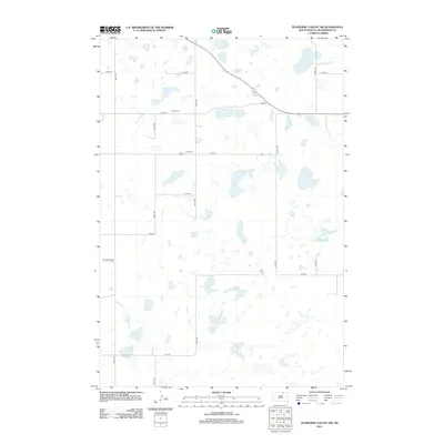
2012 Map of Plainview Colony NW
USGS Topo · Published 2012About this map
Alkali Lake sits in the northeast corner of this remote McPherson County landscape, which is defined by an extensive network of small, scattered prairie potholes and basins. The terrain is organized by a strict section-line grid of rural roads, including 114th St and 350th Ave, reflecting the enduring agricultural layout of the northern plains. This 2012 survey documents several key sites of local genealogical significance, notably Leola Cem, Rueb Cem, and Congregational Cem. These burial grounds, often the only remaining markers of early rural communities or family homesteads in the region, are spaced miles apart across the high prairie. The map provides a precise look at the hydrology and road network as they existed in the early 21st century.
Find a feature on this map
16 named features on this map. Tap any name to fly to it.
Don’t see what you’re looking for? This feature index may not catch every label — zoom into the map to look around manually.
Map Details
Editions of this 2012 Plainview Colony NW Map
This is the sole edition of this map. No revisions or reprints were ever made.
Other maps of this area

1954 · Aberdeen
USGS Topo · 1:250,000

1956 · Aberdeen
USGS Topo · 1:250,000

1968 · Long Lake
USGS Topo · 1:24,000

1968 · Long Lake SE
USGS Topo · 1:24,000

1978 · Hosmer NE
USGS Topo · 1:24,000

1978 · Hosmer SE
USGS Topo · 1:24,000
1978 · Plainview Colony
USGS Topo · 1:24,000
1978 · Plainview Colony NE
USGS Topo · 1:24,000

1978 · Schumacher Lake
USGS Topo · 1:24,000

1978 · Plainview Colony NW
USGS Topo · 1:24,000