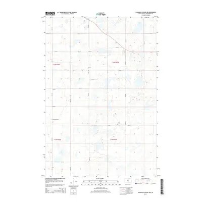
2015 Map of Plainview Colony NW
USGS Topo · Published 2015About this map
The prairie landscape of McPherson County is defined by its glacial potholes and scattered cemeteries, documenting the rural burial sites of early homesteading families. Centrally located within the township boundaries of t126n r69w and t126n r70w, the Rueb Cem and Leola Cem are prominent local landmarks along the section lines of 115th ST and 350th Ave. In the northern portion of the quadrangle, the shoreline of Alkali Lake occupies the depressions of the glaciated terrain. To the south, the Congregational Cem serves as a lone cultural marker in a region dominated by agricultural tracts. The map illustrates the strict grid system of South Dakota's rural road network, with names like 348th Ave and 119th ST providing essential navigation through the numerous wetlands and intermittent water bodies that characterize this part of the Great Plains.
Find a feature on this map
22 named features on this map. Tap any name to fly to it.
Don’t see what you’re looking for? This feature index may not catch every label — zoom into the map to look around manually.
Map Details
Editions of this 2015 Plainview Colony NW Map
This is the sole edition of this map. No revisions or reprints were ever made.
Other maps of this area

1954 · Aberdeen
USGS Topo · 1:250,000

1956 · Aberdeen
USGS Topo · 1:250,000

1968 · Long Lake
USGS Topo · 1:24,000

1968 · Long Lake SE
USGS Topo · 1:24,000

1978 · Hosmer NE
USGS Topo · 1:24,000

1978 · Hosmer SE
USGS Topo · 1:24,000
1978 · Plainview Colony
USGS Topo · 1:24,000
1978 · Plainview Colony NE
USGS Topo · 1:24,000

1978 · Schumacher Lake
USGS Topo · 1:24,000

1978 · Plainview Colony NW
USGS Topo · 1:24,000