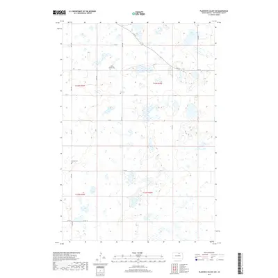
2017 Map of Plainview Colony NW
USGS Topo · Published 2017About this map
Small rural cemeteries and numerous prairie potholes define this landscape in McPherson County, South Dakota. The presence of Leola Seventh Day Adventist Cem, the Rueb Cem, and the Congregational Cem suggests a history of localized settlement and family heritage tied to the land. The terrain is marked by a complex system of seasonal wetlands and small basins, including the larger Alkali Lake in the northeastern corner. Transportation through this section of the Plains is restricted to a tight grid of section lines like 350th Ave and 116th St, with Co Hwy 18 providing the primary east-west corridor in the southern reaches. This modern survey reflects the enduring agricultural layout and the vital water resources scattered across the high plains.
Find a feature on this map
22 named features on this map. Tap any name to fly to it.
Don’t see what you’re looking for? This feature index may not catch every label — zoom into the map to look around manually.
Map Details
Editions of this 2017 Plainview Colony NW Map
This is the sole edition of this map. No revisions or reprints were ever made.
Other maps of this area

1954 · Aberdeen
USGS Topo · 1:250,000

1956 · Aberdeen
USGS Topo · 1:250,000

1968 · Long Lake
USGS Topo · 1:24,000

1968 · Long Lake SE
USGS Topo · 1:24,000

1978 · Hosmer NE
USGS Topo · 1:24,000

1978 · Hosmer SE
USGS Topo · 1:24,000
1978 · Plainview Colony
USGS Topo · 1:24,000
1978 · Plainview Colony NE
USGS Topo · 1:24,000

1978 · Schumacher Lake
USGS Topo · 1:24,000

1978 · Plainview Colony NW
USGS Topo · 1:24,000