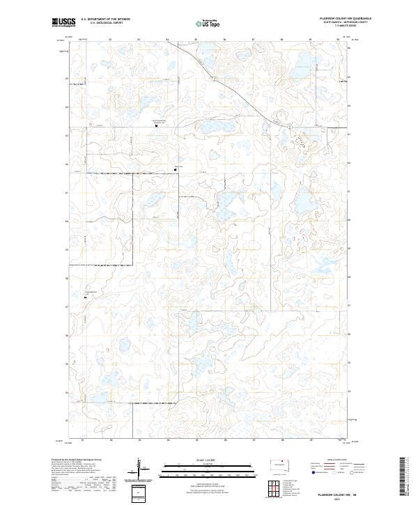
2021 Map of Plainview Colony NW
USGS Topo · Published 2021About this map
Glacial depressions and scattered wetlands characterize this portion of McPherson County, where the prairie landscape is marked by a grid of rural section roads and small, family-associated burial grounds. Among these, the Leola Seventh Day Adventist Cem and Rueb Cem sit near the center of the township lines, serving as quiet reminders of the area's homesteading history. In the northeastern corner, the expansive Alkali Lake provides a primary geographic landmark amidst dozens of smaller unnamed seasonal basins. The southern edge of the map is defined by the east-west passage of Co Hwy 18, which cuts through the townships of t125n r70w and t125n r69w, connecting this agricultural interior to the broader region.
Find a feature on this map
23 named features on this map. Tap any name to fly to it.
Don’t see what you’re looking for? This feature index may not catch every label — zoom into the map to look around manually.
Map Details
Editions of this 2021 Plainview Colony NW Map
This is the sole edition of this map. No revisions or reprints were ever made.
Other maps of this area

1954 · Aberdeen
USGS Topo · 1:250,000

1956 · Aberdeen
USGS Topo · 1:250,000

1968 · Long Lake
USGS Topo · 1:24,000

1968 · Long Lake SE
USGS Topo · 1:24,000

1978 · Hosmer NE
USGS Topo · 1:24,000

1978 · Hosmer SE
USGS Topo · 1:24,000
1978 · Plainview Colony
USGS Topo · 1:24,000
1978 · Plainview Colony NE
USGS Topo · 1:24,000

1978 · Schumacher Lake
USGS Topo · 1:24,000

1978 · Plainview Colony NW
USGS Topo · 1:24,000