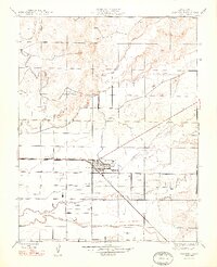
1948 Map of Planada
USGS Topo · Published 1948About this map
The central San Joaquin Valley landscape near Planada is defined here by the sharp geometry of early twentieth-century agricultural planning and the vital infrastructure of the Atchison Topeka and Santa Fe railroad. Revised in 1946, this survey illustrates a transition from the natural drainage patterns of Black Rascal Creek and Bear Creek to a highly regulated grid of irrigation and transport. The small industrial cluster at Calpack and the presence of a Gravel Pit northwest of town suggest a landscape tied to both commercial canning and construction. Road names like Kadota Avenue and Mission Avenue reflect the regional focus on specific orchard crops and historical identity, while family-named routes such as Whealan Road and Burchell Road provide critical data for those tracing local land ownership and genealogy in Merced County.
Find a feature on this map
22 named features on this map. Tap any name to fly to it.
Don’t see what you’re looking for? This feature index may not catch every label — zoom into the map to look around manually.
Map Details
Editions of this 1948 Planada Map
2 editions found
Other maps of this area

1914 · Merced
USGS Topo · 1:31,680

1915 · Owens Creek
USGS Topo · 1:31,680

1916 · Hopeton
USGS Topo · 1:31,680

1917 · Merced
USGS Topo · 1:31,680

1918 · Owens Creek
USGS Topo · 1:31,680

1918 · Lingard
USGS Topo · 1:31,680

1918 · Planada
USGS Topo · 1:31,680

1918 · La Grand
USGS Topo · 1:31,680

1919 · Indian Gulch
USGS Topo · 1:48,000

1919 · Haystack Mountain
USGS Topo · 1:31,680