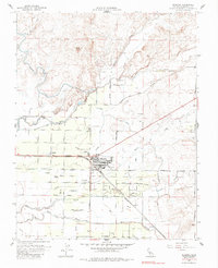
1961 Map of Planada
USGS Topo · Published 1984About this map
The settlement of Planada centers this agricultural landscape, defined by a complex grid of orchards and irrigation infrastructure during the early 1960s. The Atchison Topeka and Santa Fe railroad corridor cuts diagonally across the terrain, serving as the primary transit spine for the region's shipping needs. To the west, Calpack represents the industrial footprint of the California Packing Corporation, reflecting the intensive fruit and vegetable production that drove the local economy.
Find a feature on this map
33 named features on this map. Tap any name to fly to it.
Don’t see what you’re looking for? This feature index may not catch every label — zoom into the map to look around manually.
Map Details
Editions of this 1961 Planada Map
2 editions found
Other maps of this area

1914 · Merced
USGS Topo · 1:31,680

1915 · Owens Creek
USGS Topo · 1:31,680

1916 · Hopeton
USGS Topo · 1:31,680

1917 · Merced
USGS Topo · 1:31,680

1918 · Owens Creek
USGS Topo · 1:31,680

1918 · Lingard
USGS Topo · 1:31,680

1918 · Planada
USGS Topo · 1:31,680

1918 · La Grand
USGS Topo · 1:31,680

1919 · Indian Gulch
USGS Topo · 1:48,000

1919 · Haystack Mountain
USGS Topo · 1:31,680