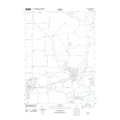
2012 Map of Plano
USGS Topo · Published 2012About this map
The BNSF Railway corridor serves as the primary artery for this region, connecting the industrial and residential centers of Plano and Sandwich. This portion of northern Illinois is defined by the transition from structured town grids to the fertile agricultural lands of Little Rock township. The landscape is drained by a network of waterways including Little Rock Cr and Big Rock Cr, which eventually flow toward the Fox River in the southern part of the quadrangle. Local history is anchored by numerous burial grounds such as Oaklawn Cem, Plano Cem, and the riverside Griswold Cem. Prominent landmarks like Maramech Hill and the recreational areas of Beaver Lake and Loon Lake reflect the area's natural geography, while the presence of Gord Airport and Bluff Creek Farm highlights the mix of modern infrastructure and traditional farming heritage.
Find a feature on this map
155 named features on this map. Tap any name to fly to it.
Don’t see what you’re looking for? This feature index may not catch every label — zoom into the map to look around manually.
Map Details
Editions of this 2012 Plano Map
This is the sole edition of this map. No revisions or reprints were ever made.
Other maps of this area

1925 · Yorkville
USGS Topo · 1:62,500

1932 · Geneva
USGS Topo · 1:62,500

1937 · Sycamore
USGS Topo · 1:62,500

1948 · Geneva
USGS Topo · 1:62,500

1948 · Sandwich
USGS Topo · 1:62,500

1950 · Sandwich
USGS Topo · 1:62,500

1953 · Plattville
USGS Topo · 1:24,000

1953 · Yorkville
USGS Topo · 1:24,000
1954 · Yorkville
USGS Topo · 1:62,500

1958 · Aurora
USGS Topo · 1:250,000