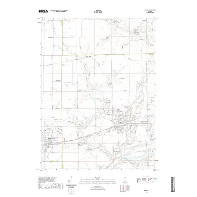
2021 Map of Plano
USGS Topo · Published 2021About this map
Plano and Sandwich anchor the southern portion of this region, where the urban street grids meet the sprawling agricultural fields of Kendall and DeKalb counties. The landscape is defined by the winding course of the Fox River and its many tributaries, including Big Rock Creek and Little Rock Creek, which flow through the rolling terrain near Maramech Hill. This contemporary look at the area highlights the integration of modern education and local history, featuring the Waubonsee Community College - Plano Campus alongside several ancestral burial grounds such as the Big Rock Welsh Cem and Little Rock Township Cem. The map provides a clear picture of the residential and industrial growth that has occurred around these established settlements, connected by a dense network of county highways and local roads like Galena Rd and Chicago Rd.
Find a feature on this map
104 named features on this map. Tap any name to fly to it.
Don’t see what you’re looking for? This feature index may not catch every label — zoom into the map to look around manually.
Map Details
Editions of this 2021 Plano Map
This is the sole edition of this map. No revisions or reprints were ever made.
Other maps of this area

1925 · Yorkville
USGS Topo · 1:62,500

1932 · Geneva
USGS Topo · 1:62,500

1937 · Sycamore
USGS Topo · 1:62,500

1948 · Geneva
USGS Topo · 1:62,500

1948 · Sandwich
USGS Topo · 1:62,500

1950 · Sandwich
USGS Topo · 1:62,500

1953 · Plattville
USGS Topo · 1:24,000

1953 · Yorkville
USGS Topo · 1:24,000
1954 · Yorkville
USGS Topo · 1:62,500

1958 · Aurora
USGS Topo · 1:250,000