
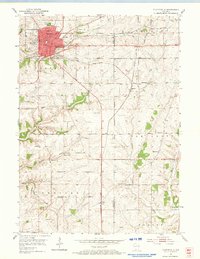
1952 Map of Platteville
USGS Topo · Published 1954About this map
The educational and mining history of Southwest Wisconsin is central to this 1952 topographic study. Platteville serves as the regional hub, housing both Pioneer State College and the Wis Inst of Tech, alongside civic landmarks like the Hospital. The landscape is heavily marked by the driftless area's lead and zinc heritage, featuring numerous extractive sites such as Acme Mine, Homestead Mine, and the Basque Mine.
Find a feature on this map
41 named features on this map. Tap any name to fly to it.
Don’t see what you’re looking for? This feature index may not catch every label — zoom into the map to look around manually.
Map Details
Editions of this 1952 Platteville Map
2 editions found
Other maps of this area

1900 · Lancaster
USGS Topo · 1:125,000

1902 · Mineral Point
USGS Topo · 1:125,000

1904 · Lancaster
USGS Topo · 1:125,000

1908 · Lancaster
USGS Topo · 1:125,000

1952 · Rewey
USGS Topo · 1:24,000

1952 · Cuba City
USGS Topo · 1:24,000

1952 · Belmont
USGS Topo · 1:24,000

1952 · New Diggings
USGS Topo · 1:24,000

1952 · Mifflin
USGS Topo · 1:24,000

1959 · Dubuque
USGS Topo · 1:250,000