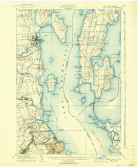
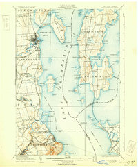
1906 Map of Plattsburg
USGS Topo · Published 1938About this map
Plattsburg serves as the focal point of this turn-of-the-century survey, showcasing the established military presence at Plattsburg Barracks and the sprawling waterfront along Cumberland Bay. The landscape is defined by the heavy maritime and rail commerce of Lake Champlain, with multiple lighthouse installations like Cumberland Head L.H. and Valcour L.H. guiding vessels along the Steamer Route. On the Vermont side of the water, Grand Isle and South Hero are interconnected by the Rutland Railroad, which cuts through the islands and marshes, including the significant Pearl Swamp.
Find a feature on this map
120 named features on this map. Tap any name to fly to it.
Don’t see what you’re looking for? This feature index may not catch every label — zoom into the map to look around manually.
Map Details
Editions of this 1906 Plattsburg Map
6 editions found
Other maps of this area

1894 · Plattsburg
USGS Topo · 1:62,500

1895 · Mooers
USGS Topo · 1:62,500

1895 · Rouse Point
USGS Topo · 1:62,500

1895 · Willsboro
USGS Topo · 1:62,500

1895 · Ausable
USGS Topo · 1:62,500

1899 · Mooers
USGS Topo · 1:62,500

1903 · Ausable
USGS Topo · 1:62,500

1906 · Plattsburg
USGS Topo · 1:62,500

1906 · Burlington
USGS Topo · 1:62,500

1907 · Rouse Point
USGS Topo · 1:62,500