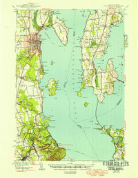
1943 Map of Plattsburg
USGS Topo · Published 1949About this map
Plattsburg serves as the regional hub in this mid-century survey of the Lake Champlain shoreline, where the Saranac River meets the bay. The map illustrates a landscape of established lakeside communities and island outposts, including the resort-centered Hotel Champlain and the northern reaches of Adirondack State Park. Transportation networks are heavily represented by the Rutland Railroad crossing the islands to the east and the Delaware and Hudson line running south toward Port Kent.
Find a feature on this map
109 named features on this map. Tap any name to fly to it.
Don’t see what you’re looking for? This feature index may not catch every label — zoom into the map to look around manually.
Map Details
Editions of this 1943 Plattsburg Map
4 editions found
Other maps of this area

1894 · Plattsburg
USGS Topo · 1:62,500

1895 · Mooers
USGS Topo · 1:62,500

1895 · Rouse Point
USGS Topo · 1:62,500

1895 · Willsboro
USGS Topo · 1:62,500

1895 · Ausable
USGS Topo · 1:62,500

1899 · Mooers
USGS Topo · 1:62,500

1903 · Ausable
USGS Topo · 1:62,500

1906 · Plattsburg
USGS Topo · 1:62,500

1906 · Burlington
USGS Topo · 1:62,500

1907 · Rouse Point
USGS Topo · 1:62,500