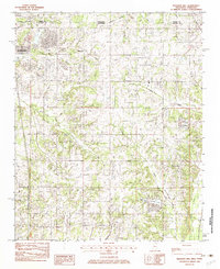
1982 Map of Pleasant Hill
USGS Topo · Published 1982About this map
Southaven stands as a focal point of suburban growth along the Tennessee-Mississippi state line in the early 1980s, where the expansion of residential blocks meets the rolling drainages of the Shelby and DeSoto County border. To the east, the unincorporated community of Pleasant Hill maintains its rural character, surrounded by a complex network of waterways including Horn Lake Creek and Hurricane Creek. The landscape transitions from the developed streets of the north to the managed waters of Sunset Lake and Sunrise Lake near the quadrangle's southern edge. Industrial activity is represented by a local Sand & Gravel Pit, while recreational interests are reflected in the presence of Riding Stables and a Golf Course, illustrating the region's mid-century shift from purely agricultural use to a diverse residential and leisure-oriented corridor.
Find a feature on this map
18 named features on this map. Tap any name to fly to it.
Don’t see what you’re looking for? This feature index may not catch every label — zoom into the map to look around manually.
Map Details
Editions of this 1982 Pleasant Hill Map
This is the sole edition of this map. No revisions or reprints were ever made.
Other maps of this area

1916 · Memphis
USGS Topo · 1:62,500

1925 · Memphis
USGS Topo · 1:48,000

1927 · Memphis
USGS Topo · 1:62,500

1932 · Horn Lake
USGS Topo · 1:48,000

1935 · Horn Lake
USGS Topo · 1:62,500

1939 · Memphis
USGS Topo · 1:62,500

1944 · Hernando
USGS Topo · 1:62,500

1948 · Helena
USGS Topo · 1:250,000

1950 · Helena
USGS Topo · 1:250,000

1953 · Memphis
USGS Topo · 1:250,000