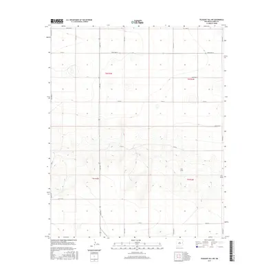
2017 Map of Pleasant Hill NW
USGS Topo · Published 2017About this map
Frio Draw winds through this High Plains landscape in northeastern New Mexico, defining the drainage patterns for this section of Curry County. The land is organized by an exacting grid of section lines and gravel routes, including Curry Road 34 and Curry Road 33, which reflect the region's agricultural heritage and homesteading history. Topographic contours reveal the subtle relief of the Llano Estacado, where intermittent watercourses and small depressions break the flat horizon. Boundary labels such as t6n r35e and t5n r36e mark the Public Land Survey System coordinates, essential for genealogists and researchers tracing 20th-century land patents and family farm locations. This survey documents the network of rural infrastructure, from Curry Road 27 to the eastern boundary at Curry Road F, that continues to support the area's ranching and dryland farming economy.
Find a feature on this map
24 named features on this map. Tap any name to fly to it.
Don’t see what you’re looking for? This feature index may not catch every label — zoom into the map to look around manually.
Map Details
Editions of this 2017 Pleasant Hill NW Map
This is the sole edition of this map. No revisions or reprints were ever made.
Other maps of this area

1954 · Clovis
USGS Topo · 1:250,000

1957 · Pleasant Hill
USGS Topo · 1:62,500

1957 · Hammond Ranch
USGS Topo · 1:62,500

1958 · Clovis
USGS Topo · 1:250,000

1971 · Broadview
USGS Topo · 1:24,000

1971 · Grady
USGS Topo · 1:24,000

1971 · Bellview
USGS Topo · 1:24,000

1985 · Pleasant Hill NW
USGS Topo · 1:24,000

1985 · Smith Ranch
USGS Topo · 1:24,000

1985 · Pleasant Hill
USGS Topo · 1:24,000