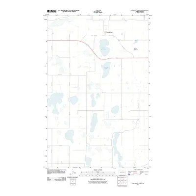
2011 Map of Pleasant Lake
USGS Topo · Published 2011About this map
Pleasant Lake sits as a small settlement in the northern reaches of this North Dakota landscape, situated along the corridor of County Hwy-3521. The surrounding terrain is defined by a dense network of glacial potholes and larger water bodies, illustrating the characteristic hydrology of the prairie pothole region. Significant landmarks like Broken Bone Lake and Horseshoe Lake dominate the central topography, while Broken Bone Hill provides a distinct elevation point amidst the numerous wetlands. The map details a systematic grid of section roads including 66th St NE and 35th Ave NE, which provide access to the dispersed farms and rural properties that comprise this agricultural community. To the south, the elongated form of Long Lake marks the lower portion of the quadrangle, serving as a primary drainage feature for the local watershed.
Find a feature on this map
23 named features on this map. Tap any name to fly to it.
Don’t see what you’re looking for? This feature index may not catch every label — zoom into the map to look around manually.
Map Details
Editions of this 2011 Pleasant Lake Map
This is the sole edition of this map. No revisions or reprints were ever made.
Other maps of this area

1953 · Devils Lake
USGS Topo · 1:250,000

1954 · Rugby NW
USGS Topo · 1:24,000

1955 · Rugby
USGS Topo · 1:24,000

1956 · Devils Lake
USGS Topo · 1:250,000

1958 · Fillmore
USGS Topo · 1:24,000
1958 · Silva
USGS Topo · 1:24,000

1958 · Baker
USGS Topo · 1:24,000

1971 · Wolford
USGS Topo · 1:24,000

1971 · Knox
USGS Topo · 1:24,000

1971 · Rugby NE
USGS Topo · 1:24,000