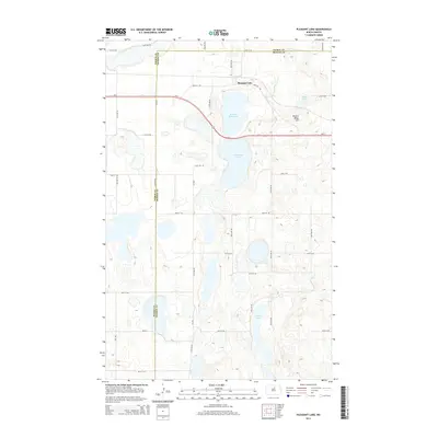
2014 Map of Pleasant Lake
USGS Topo · Published 2014About this map
The settlement of Pleasant Lake sits at the northern edge of this 2014 survey, positioned where the Pierce Co Benson Co line intersects the local road network. This prairie landscape is defined by its glaciated hydrology, featuring a cluster of named water bodies including Broken Bone Lake, Horseshoe Lake, and Long Lake. The terrain rises at Broken Bone Hill just east of the central basins, providing a rare point of elevation in a region characterized by numerous unnamed depressions and wetlands. The transportation corridor of Us-2 cuts across the northern half of the map, linking the rural sections with the village center. A rigid grid of section line roads, such as 40th Ave NE and 60th St NE, organizes the surrounding agricultural land and marks the jurisdictional boundaries between the two counties.
Find a feature on this map
25 named features on this map. Tap any name to fly to it.
Don’t see what you’re looking for? This feature index may not catch every label — zoom into the map to look around manually.
Map Details
Editions of this 2014 Pleasant Lake Map
This is the sole edition of this map. No revisions or reprints were ever made.
Other maps of this area

1953 · Devils Lake
USGS Topo · 1:250,000

1954 · Rugby NW
USGS Topo · 1:24,000

1955 · Rugby
USGS Topo · 1:24,000

1956 · Devils Lake
USGS Topo · 1:250,000

1958 · Fillmore
USGS Topo · 1:24,000
1958 · Silva
USGS Topo · 1:24,000

1958 · Baker
USGS Topo · 1:24,000

1971 · Wolford
USGS Topo · 1:24,000

1971 · Knox
USGS Topo · 1:24,000

1971 · Rugby NE
USGS Topo · 1:24,000