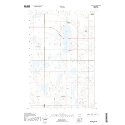
2017 Map of Pleasant Lake
USGS Topo · Published 2017About this map
Pleasant Lake sits at the northern edge of this North Dakota landscape, situated along the border of Pierce and Benson Counties. The region is defined by a dense concentration of glacial wetlands and water bodies, including the uniquely shaped Horseshoe Lake and the nearby Broken Bone Lake. A prominent geological feature, Broken Bone Hill, rises east of the main settlement, providing a distinct landmark in an otherwise prairie environment dominated by section-line roads like 66th St NE and Co Rd 0305. The township grid system, marked by designations such as t156n r71w, organizes the territory into a rhythmic pattern of agricultural fields and natural basins. The southern portion of the map is dominated by the elongated reaches of Long Lake, illustrating the complex hydrology of the northern plains.
Find a feature on this map
19 named features on this map. Tap any name to fly to it.
Don’t see what you’re looking for? This feature index may not catch every label — zoom into the map to look around manually.
Map Details
Editions of this 2017 Pleasant Lake Map
This is the sole edition of this map. No revisions or reprints were ever made.
Other maps of this area

1953 · Devils Lake
USGS Topo · 1:250,000

1954 · Rugby NW
USGS Topo · 1:24,000

1955 · Rugby
USGS Topo · 1:24,000

1956 · Devils Lake
USGS Topo · 1:250,000

1958 · Fillmore
USGS Topo · 1:24,000
1958 · Silva
USGS Topo · 1:24,000

1958 · Baker
USGS Topo · 1:24,000

1971 · Wolford
USGS Topo · 1:24,000

1971 · Knox
USGS Topo · 1:24,000

1971 · Rugby NE
USGS Topo · 1:24,000