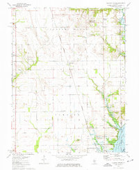
1974 Map of Pleasant Mound
USGS Topo · Published 1977About this map
Pleasant Mound and the surrounding agricultural landscapes of eastern Bond County are defined here by a transition from upland prairies to the burgeoning waters of Carlyle Lake. The map illustrates the region in the mid-1970s, showcasing a network of rural settlements like Hookdale and Tamalco linked by the Burlington Northern railroad. A significant portion of the southeastern quadrant is dedicated to the Carlyle Lake State Wildlife Management Area, where the rising lake levels at the confluence of Hurricane Creek and Spring Branch altered the local topography.
Find a feature on this map
29 named features on this map. Tap any name to fly to it.
Don’t see what you’re looking for? This feature index may not catch every label — zoom into the map to look around manually.
Map Details
Editions of this 1974 Pleasant Mound Map
This is the sole edition of this map. No revisions or reprints were ever made.
Other maps of this area

1910 · Carlyle
USGS Topo · 1:62,500

1914 · Centralia
USGS Topo · 1:62,500

1932 · Greenville
USGS Topo · 1:62,500

1935 · Centralia
USGS Topo · 1:62,500

1939 · Greenville
USGS Topo · 1:62,500

1943 · Greenville
USGS Topo · 1:62,500

1945 · Vandalia
USGS Topo · 1:62,500

1947 · Vandalia
USGS Topo · 1:62,500

1948 · Carlyle
USGS Topo · 1:62,500

1958 · Belleville
USGS Topo · 1:250,000