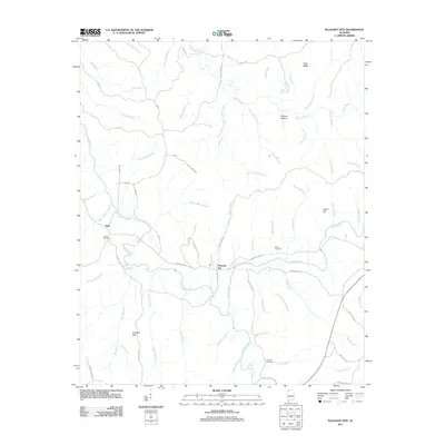
2011 Map of Pleasant Site
USGS Topo · Published 2011About this map
Pleasant Site and the settlement of Pogo anchor this landscape in northwestern Franklin County, where the terrain transitions toward the Freedom Hills. The map reveal a complex network of waterways that defined early industry and settlement, marked by several historic mill locations including Ramsey Mill Branch, Starky Mill Branch, and Boldin Mill Branch. These namesake streams suggest a legacy of water-powered milling that once served the local rural economy. For family historians, the placement of the James Cemetery, Bolton Cemetery, and Patterson Cemetery offers vital geographic context for ancestral research in this corner of Alabama. Distinctive landforms like Todd Ridge, Malone Hollow, and Indian Hill rise above the drainage of Cedar Creek, while a web of named roads like White Pike and Sally Burns Rd connect the scattered homesteads and ridges.
Find a feature on this map
68 named features on this map. Tap any name to fly to it.
Don’t see what you’re looking for? This feature index may not catch every label — zoom into the map to look around manually.
Map Details
Editions of this 2011 Pleasant Site Map
This is the sole edition of this map. No revisions or reprints were ever made.
Other maps of this area

1925 · Barton
USGS Topo · 1:62,500

1926 · Barton
USGS Topo · 1:48,000

1929 · Barton
USGS Topo · 1:62,500

1935 · Pleasant Site
USGS Topo · 1:24,000

1936 · Belmont
USGS Topo · 1:24,000

1936 · Pleasant Grove
USGS Topo · 1:24,000

1936 · Red Bay
USGS Topo · 1:24,000
1936 · Barton
USGS Topo · 1:24,000

1936 · Halltown
USGS Topo · 1:24,000

1936 · Bishop
USGS Topo · 1:24,000