
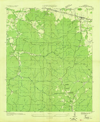
1935 Map of Pleasant Site
USGS Topo · Published 1935About this map
The community of Pogo and the rural crossroads of Pleasant Site Ch anchor this mid-1930s landscape along the border of Colbert and Franklin Counties. The terrain is defined by a dense network of creek branches and timbered ridges, where small settlements grew around local institutions. Cultural life is clearly mapped through the distribution of landmarks like Harmony Ch and the remote New Smyrna Sch, which served as both an educational and social hub for the surrounding valley residents. The presence of family-linked sites such as Bolton Cem and Patterson Cem provides essential spatial data for genealogical research in this pocket of North Alabama. This survey, compiled from aerial photographs, captures the settlement patterns of a traditional agricultural and woodland economy before the modernization of the Tennessee Valley reached its full stride.
Find a feature on this map
10 named features on this map. Tap any name to fly to it.
Don’t see what you’re looking for? This feature index may not catch every label — zoom into the map to look around manually.
Map Details
Editions of this 1935 Pleasant Site Map
This is the sole edition of this map. No revisions or reprints were ever made.
Other maps of this area

1925 · Barton
USGS Topo · 1:62,500

1926 · Barton
USGS Topo · 1:48,000

1929 · Barton
USGS Topo · 1:62,500

1936 · Belmont
USGS Topo · 1:24,000

1936 · Pleasant Grove
USGS Topo · 1:24,000

1936 · Red Bay
USGS Topo · 1:24,000
1936 · Barton
USGS Topo · 1:24,000

1936 · Halltown
USGS Topo · 1:24,000

1936 · Bishop
USGS Topo · 1:24,000

1936 · Guinn Cross Roads
USGS Topo · 1:24,000