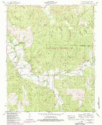
1950 Map of Pleasant Site
USGS Topo · Published 1987About this map
Pleasant Site and the rural hills of northwestern Alabama are depicted here as they appeared following the 1950 field check, showing a landscape defined by the winding waters of Cedar Creek and Rock Creek. This area, straddling the border of Colbert and Franklin Counties, is anchored by long-standing community landmarks such as the Freedom Hills Church and several family burial grounds, including James Cem and Bolton Cem. The presence of the Thomas Wildlife Management Area and the Pope Lookout Tower highlights the heavily forested nature of the Freedom Hills, while the historic route of the Natchez Trace Parkway cuts across the western edge of the quadrangle.
Find a feature on this map
57 named features on this map. Tap any name to fly to it.
Don’t see what you’re looking for? This feature index may not catch every label — zoom into the map to look around manually.
Map Details
Editions of this 1950 Pleasant Site Map
This is the sole edition of this map. No revisions or reprints were ever made.
Other maps of this area

1925 · Barton
USGS Topo · 1:62,500

1926 · Barton
USGS Topo · 1:48,000

1929 · Barton
USGS Topo · 1:62,500

1935 · Pleasant Site
USGS Topo · 1:24,000

1936 · Belmont
USGS Topo · 1:24,000

1936 · Pleasant Grove
USGS Topo · 1:24,000

1936 · Red Bay
USGS Topo · 1:24,000
1936 · Barton
USGS Topo · 1:24,000

1936 · Halltown
USGS Topo · 1:24,000

1936 · Bishop
USGS Topo · 1:24,000