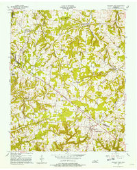
1957 Map of Pleasant View
USGS Topo · Published 1981About this map
The agrarian highlands where Robertson County and Cheatham County meet are meticulously documented in this late-1950s study. The landscape is defined by its rural density, marked by numerous country churches such as Brewer Chapel, Heads Ch, and Mt Lebanon Ch. Small communities like Stroudville, Turnersville, and Gause serve as local hubs, while the larger settlement at Pleasant View is anchored by a utility Substation. The complex drainage of the Central Basin is evident in the winding courses of Millers Creek, Honey Run, and Half Pone Creek, which carve through the plateau. This era shows a transition from traditional farmsteads to a more integrated regional infrastructure, captured just before modern development began to alter the character of these Tennessee crossroads.
Find a feature on this map
28 named features on this map. Tap any name to fly to it.
Don’t see what you’re looking for? This feature index may not catch every label — zoom into the map to look around manually.
Map Details
Editions of this 1957 Pleasant View Map
3 editions found
Other maps of this area

1903 · Nashville
USGS Topo · 1:125,000

1931 · Ridgetop
USGS Topo · 1:62,500

1935 · Ridgetop
USGS Topo · 1:62,500

1952 · Springfield North
USGS Topo · 1:24,000

1955 · Forest Grove
USGS Topo · 1:24,000

1956 · Nashville
USGS Topo · 1:250,000

1957 · Cheatham Dam
USGS Topo · 1:24,000

1957 · Adams
USGS Topo · 1:24,000

1957 · Pleasant View
USGS Topo · 1:24,000

1957 · Henrietta
USGS Topo · 1:24,000