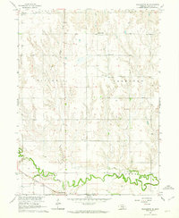
1962 Map of Pleasanton SE
USGS Topo · Published 1964About this map
Wood River meanders across the southern portion of this 1962 landscape, flanked by the Union Pacific railroad and the small settlement of Glenwood Park. This Buffalo County terrain is defined by a series of townships including Rusco, Cedar, Divide, Thornton, and Center. The map reveals a highly structured rural society where numerous schoolhouses, such as School No 26 and School No 110, are spaced at regular intervals to serve the surrounding farmsteads. Local community life is anchored by Prairie Center, where the Prairie Center Cem and St Mary Cem sit near Havens Chapel. This survey effectively documents the intersection of rail-line transportation and the persistent watercourses of Dry Creek and Sand Cr that shaped the agricultural layout of central Nebraska during the early 1960s.
Find a feature on this map
23 named features on this map. Tap any name to fly to it.
Don’t see what you’re looking for? This feature index may not catch every label — zoom into the map to look around manually.
Map Details
Editions of this 1962 Pleasanton SE Map
2 editions found
Other maps of this area

1894 · Kearney
USGS Topo · 1:62,500

1894 · Minden
USGS Topo · 1:62,500

1896 · Kearney
USGS Topo · 1:125,000

1896 · Wood River
USGS Topo · 1:125,000

1955 · Grand Island
USGS Topo · 1:250,000

1957 · Grand Island
USGS Topo · 1:250,000

1958 · Grand Island
USGS Topo · 1:250,000

1962 · Newark
USGS Topo · 1:24,000

1962 · Riverdale
USGS Topo · 1:24,000
1962 · Pleasanton NW
USGS Topo · 1:24,000