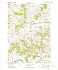
1973 Map of Pleasantville
USGS Topo · Published 1975About this map
Pleasantville and the surrounding townships of Hale, Lincoln, and Pigeon reveal a mid-1970s landscape defined by deeply carved coulees and traditional Trempealeau County valley settlements. The terrain is a network of named drainages like Sleepy Valley, Dismore Coulee, and Sjuggerud Coulee that feed into the larger Pigeon Creek and the southern Trempealeau River. Local social and spiritual hubs are clearly marked, including the Elk Creek Ch, St Johns Ch, and the Community Hall near the northern border. For genealogists, the Wagner Cem is a notable landmark in the western hills. The map also documents the local extractive economy of the era, pinpointing numerous quarries, gravel pits, and a sandpit scattered among the ridges and valley floors.
Find a feature on this map
27 named features on this map. Tap any name to fly to it.
Don’t see what you’re looking for? This feature index may not catch every label — zoom into the map to look around manually.
Map Details
Editions of this 1973 Pleasantville Map
This is the sole edition of this map. No revisions or reprints were ever made.
Other maps of this area

1926 · Whitehall
USGS Topo · 1:62,500

1927 · Blair
USGS Topo · 1:62,500

1927 · Strum
USGS Topo · 1:62,500

1929 · Whitehall
USGS Topo · 1:62,500

1930 · Strum
USGS Topo · 1:62,500

1935 · Osseo
USGS Topo · 1:48,000

1940 · Osseo
USGS Topo · 1:62,500

1953 · Eau Claire
USGS Topo · 1:250,000

1958 · Eau Claire
USGS Topo · 1:250,000

1964 · Eau Claire
USGS Topo · 1:250,000