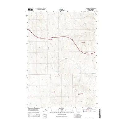
2015 Map of Ploessers Draw
USGS Topo · Published 2015About this map
Indian Creek Divide anchors the southeastern landscape of this Johnson County quadrangle, where the high ground separates numerous intermittent drainages. Water management is a central theme of this arid region, as evidenced by several localized storage sites such as Marton Reservoir, Green Reservoir, and Alexander Reservoir. The terrain is defined by a series of erosion features and basins, most notably the namesake Ploessers Draw and the extensive Ploessers Dry Lake. Transportation through this part of the Wyoming interior is facilitated by unpaved corridors like Schoonover Rd and Dry Creek Rd, which provide access to the remote township sections of T49N and T48N. The mapping of Indian-Cr Reservoir and smaller watercourses like Cat Cr reflects the critical importance of every water source in this ranching country.
Find a feature on this map
21 named features on this map. Tap any name to fly to it.
Don’t see what you’re looking for? This feature index may not catch every label — zoom into the map to look around manually.
Map Details
Editions of this 2015 Ploessers Draw Map
This is the sole edition of this map. No revisions or reprints were ever made.
Other maps of this area

1955 · Sheridan
USGS Topo · 1:250,000

1958 · Sheridan
USGS Topo · 1:250,000

1962 · Sheridan
USGS Topo · 1:250,000
1972 · Crazy Woman Ranch
USGS Topo · 1:24,000
1972 · Ploessers Draw
USGS Topo · 1:24,000
1972 · Pine Gulch
USGS Topo · 1:24,000
1972 · Bear Draw
USGS Topo · 1:24,000
1972 · Somerville Flats West
USGS Topo · 1:24,000
1972 · Brown Ranch
USGS Topo · 1:24,000
1972 · Bowman Flat
USGS Topo · 1:24,000