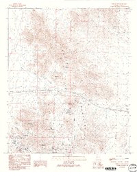
1990 Map of Plomosa Pass
USGS Topo · Published 1990About this map
Plomosa Mountains dominate this 1990 topographic study of western Arizona, revealing a landscape deeply marked by prospecting and arid-land hydrology. The terrain is centered around Plomosa Pass, with prominent peaks such as Guadalupe Mountain, Scaddan Mountain, and Elephant Back Mountain defining the horizon. Evidence of the region's mineral history is concentrated near the pass, where several named operations are located, including the Gold Nugget Mine, the Belle of Arizona Mine, and the Black Beauty Mine. Numerous unidentified Mine Shafts and scattered Prospects indicate extensive mineral exploration across the slopes.
Find a feature on this map
31 named features on this map. Tap any name to fly to it.
Don’t see what you’re looking for? This feature index may not catch every label — zoom into the map to look around manually.
Map Details
Editions of this 1990 Plomosa Pass Map
2 editions found

Other maps of this area

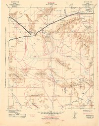
1930 · Linskey
USGS Topo · 1:62,500

1942 · Blythe
USGS Topo · 1:250,000
1942 · Vicksburg
USGS Topo · 1:250,000

1954 · Salton Sea
USGS Topo · 1:250,000

1954 · Phoenix
USGS Topo · 1:250,000

1955 · Salton Sea
USGS Topo · 1:250,000

1957 · Phoenix
USGS Topo · 1:250,000

1958 · Phoenix
USGS Topo · 1:250,000

1959 · Salton Sea
USGS Topo · 1:250,000

1960 · Phoenix
USGS Topo · 1:250,000