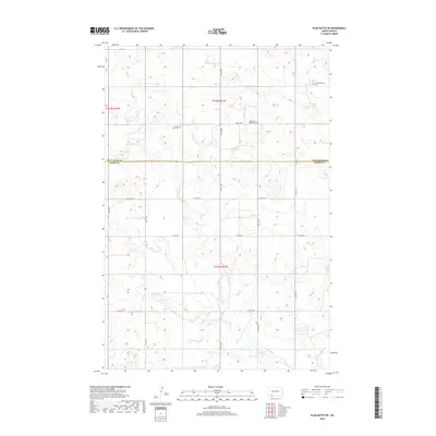
2018 Map of Plum Butte NE
USGS Topo · Published 2018About this map
The rolling plains of southwestern North Dakota are defined by the convergence of the Hettinger and Adams County line, where small rural cemeteries remain as the primary markers of historical settlement. These sacred grounds, including the Zoar Methodist Cem, Sacred Heart Cem, and Pilgerheim Baptist Cem, are often situated on higher elevations near the headwaters of local drainage systems. The landscape is carved by the meandering paths of Sheep Cr and Timber Creek, which provide the topographical variation in an otherwise grid-aligned agricultural territory. The road network, including Bentley Rd and 29th St NE, follows the section lines of the Public Land Survey System, illustrating the rigid 19th-century land division that continues to dictate movement across the prairie today.
Find a feature on this map
23 named features on this map. Tap any name to fly to it.
Don’t see what you’re looking for? This feature index may not catch every label — zoom into the map to look around manually.
Map Details
Editions of this 2018 Plum Butte NE Map
This is the sole edition of this map. No revisions or reprints were ever made.
Other maps of this area

1953 · Dickinson
USGS Topo · 1:250,000

1954 · Bismarck
USGS Topo · 1:250,000

1957 · Dickinson
USGS Topo · 1:250,000

1958 · Bismarck
USGS Topo · 1:250,000

1969 · Burt
USGS Topo · 1:24,000

1969 · Bentley
USGS Topo · 1:24,000

1972 · Coffin Buttes
USGS Topo · 1:24,000

1972 · New Leipzig South
USGS Topo · 1:24,000

1972 · Round Top
USGS Topo · 1:24,000
1974 · Nason Hill
USGS Topo · 1:24,000