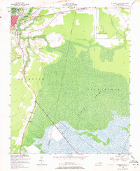
1954 Map of Plymouth East
USGS Topo · Published 1972About this map
The Roanoke River and its bordering wetlands dominate this mid-century landscape where the town of Plymouth serves as a critical junction for the Norfolk Southern and Atlantic Coast Line railroads. The map documents a transition from the structured street grid of the town to the expansive East Dismal Swamp to the south and east. A legacy of early regional transit is preserved in the Old Turnpike, which cuts a straight line through the wetlands toward the southeast corner of the quadrangle.
Find a feature on this map
19 named features on this map. Tap any name to fly to it.
Don’t see what you’re looking for? This feature index may not catch every label — zoom into the map to look around manually.
Map Details
Editions of this 1954 Plymouth East Map
3 editions found
Other maps of this area

1914 · Belhaven
USGS Topo · 1:48,000

1916 · Belhaven
USGS Topo · 1:62,500

1943 · Plymouth
USGS Topo · 1:125,000

1953 · Rocky Mount
USGS Topo · 1:250,000

1954 · Rocky Mount
USGS Topo · 1:250,000

1954 · Plymouth East
USGS Topo · 1:24,000

1954 · Roper North
USGS Topo · 1:24,000

1954 · Roper South
USGS Topo · 1:24,000

1954 · Westover
USGS Topo · 1:24,000
1954 · Pungo Lake
USGS Topo · 1:24,000