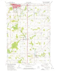
1974 Map of Plymouth South
USGS Topo · Published 1977About this map
The Mullet River and Onion River define the agricultural landscape of south-central Sheboygan County, providing the water power that historically anchored small settlements. In this mid-1970s view, the industrial legacy of the region is visible through features like the Waldo Mill Pond and Hingham Mill Pond, while the northern portion is dominated by the urban expansion of Plymouth and the smaller neighborhood of New Paris.
Find a feature on this map
49 named features on this map. Tap any name to fly to it.
Don’t see what you’re looking for? This feature index may not catch every label — zoom into the map to look around manually.
Map Details
Editions of this 1974 Plymouth South Map
2 editions found
Other maps of this area

1954 · Sheboygan Falls
USGS Topo · 1:62,500

1954 · Sheboygan Falls
USGS Topo · 1:24,000

1954 · Howards Grove
USGS Topo · 1:62,500

1954 · Howards Grove
USGS Topo · 1:24,000

1954 · Franklin
USGS Topo · 1:24,000

1954 · Kiel
USGS Topo · 1:62,500

1954 · Milwaukee
USGS Topo · 1:250,000

1955 · Kewaskum
USGS Topo · 1:62,500

1957 · Madison
USGS Topo · 1:250,000

1958 · Milwaukee
USGS Topo · 1:250,000