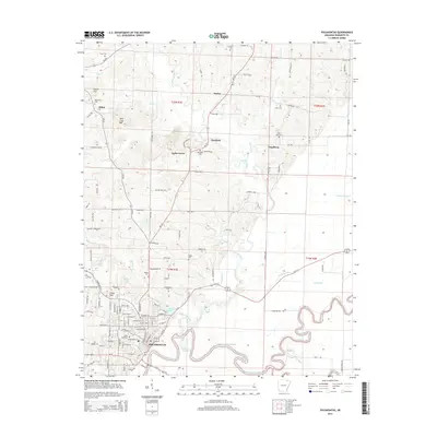
2014 Map of Pocahontas
USGS Topo · Published 2014About this map
Pocahontas anchors this Randolph County landscape where the Black River meets the winding Fouche River. The topography transitions from the higher ground near Attica Hill and Aunt Lucy Hill in the northwest to the complex river bottoms and oxbows of the south. This 2014 survey reveals a rural landscape dense with small settlements and family-named landmarks, tracing the local history of communities like Stokes, Brockett, and Engelberg. Genealogists will find a wealth of burial sites throughout the quadrangle, including the Oak Grove, Friendship, and Saint John cemeteries. The map meticulously documents the hydrological network that has long shaped life here, from the managed drainage of Frisco Ditch and Mule Ditch to natural features like Bates Lake and Baltz Lake. The intricate bends of the Black River, such as Reeves Reach, illustrate the shifting nature of the river channel over time.
Find a feature on this map
137 named features on this map. Tap any name to fly to it.
Don’t see what you’re looking for? This feature index may not catch every label — zoom into the map to look around manually.
Map Details
Editions of this 2014 Pocahontas Map
This is the sole edition of this map. No revisions or reprints were ever made.
Other maps of this area

1932 · Walnut Ridge
USGS Topo · 1:62,500

1934 · Powhatan
USGS Topo · 1:62,500

1935 · Powhatan
USGS Topo · 1:62,500

1935 · Reyno
USGS Topo · 1:62,500

1935 · Walnut Ridge
USGS Topo · 1:62,500

1957 · Poplar Bluff
USGS Topo · 1:250,000

1959 · Poplar Bluff
USGS Topo · 1:250,000

1960 · Poplar Bluff
USGS Topo · 1:250,000
1965 · O'Kean
USGS Topo · 1:24,000
1965 · Manson
USGS Topo · 1:24,000