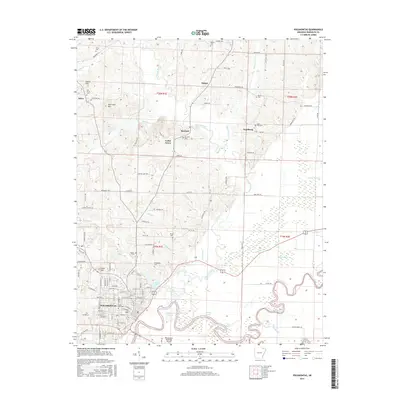
2017 Map of Pocahontas
USGS Topo · Published 2017About this map
Pocahontas serves as the regional hub at the confluence where the Black River and Current River meet the Fourche River. This 2017 survey details a landscape defined by complex hydrology, including the wide Reeves Reach and the Old River Slough, reflecting the historical importance of these river systems to Randolph County. The town plan of Pocahontas is clearly articulated, featuring the Highland neighborhood and streets such as Broadway ST and Walnut ST. Outside the city center, the terrain is dotted with small rural communities like Stokes, Brockett, and Engelberg, each anchored by local landmarks such as Brockett Cem and Saint John Cem. To the northwest, the elevation rises toward Attica Hill and Aunt Lucy Hill, while the lowlands are drained by an intricate network of waterways including Frisco Ditch and Mule Ditch. This map provides a clear record of family-named cemeteries and rural roads that are essential for tracing local lineage.
Find a feature on this map
155 named features on this map. Tap any name to fly to it.
Don’t see what you’re looking for? This feature index may not catch every label — zoom into the map to look around manually.
Map Details
Editions of this 2017 Pocahontas Map
This is the sole edition of this map. No revisions or reprints were ever made.
Other maps of this area

1932 · Walnut Ridge
USGS Topo · 1:62,500

1934 · Powhatan
USGS Topo · 1:62,500

1935 · Powhatan
USGS Topo · 1:62,500

1935 · Reyno
USGS Topo · 1:62,500

1935 · Walnut Ridge
USGS Topo · 1:62,500

1957 · Poplar Bluff
USGS Topo · 1:250,000

1959 · Poplar Bluff
USGS Topo · 1:250,000

1960 · Poplar Bluff
USGS Topo · 1:250,000
1965 · O'Kean
USGS Topo · 1:24,000
1965 · Manson
USGS Topo · 1:24,000