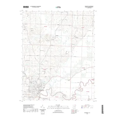
2020 Map of Pocahontas
USGS Topo · Published 2020About this map
Pocahontas serves as the focal point of this Randolph County survey, situated at the confluence where the Black River meets the winding Current River. The town layout includes the Randolph County Courthouse and local landmarks like Saint Paul Cem, while the industrial and social landscape extends to East Pocahontas. Northward, the terrain transitions into a patchwork of rural settlements and family-named features, such as Aunt Lucy Hill and Attica Hill near Attica. The hydrological complexity of the area is evident in the numerous oxbows and channels like Old River Slough, Twin Eddies, and Reeves Reach, illustrating the dynamic nature of the river systems that have historically defined the region's boundaries and commerce. Smaller communities like Stokes, Brockett, and Engelberg are connected by a network of rural trails and roads, reflecting the persistent agricultural character of the Arkansas Ozarks foothills.
Find a feature on this map
107 named features on this map. Tap any name to fly to it.
Don’t see what you’re looking for? This feature index may not catch every label — zoom into the map to look around manually.
Map Details
Editions of this 2020 Pocahontas Map
This is the sole edition of this map. No revisions or reprints were ever made.
Other maps of this area

1932 · Walnut Ridge
USGS Topo · 1:62,500

1934 · Powhatan
USGS Topo · 1:62,500

1935 · Powhatan
USGS Topo · 1:62,500

1935 · Reyno
USGS Topo · 1:62,500

1935 · Walnut Ridge
USGS Topo · 1:62,500

1957 · Poplar Bluff
USGS Topo · 1:250,000

1959 · Poplar Bluff
USGS Topo · 1:250,000

1960 · Poplar Bluff
USGS Topo · 1:250,000
1965 · O'Kean
USGS Topo · 1:24,000
1965 · Manson
USGS Topo · 1:24,000