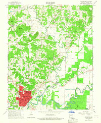
1966 Map of Pocahontas
USGS Topo · Published 1967About this map
The Fourche River and Current River define the fertile bottomlands of Randolph County, where they converge toward the Black River in the mid-1960s. Pocahontas serves as the regional hub, its streets such as Dalton Ave and Smithville Rd extending from the central district toward landmarks like the Masonic Cemetery and St Pauls High Sch. The town's industrial and communication footprint is marked by the St Louis-San Francisco Railroad and the Radio Station (KPOC) located along the river bluffs.
Find a feature on this map
61 named features on this map. Tap any name to fly to it.
Don’t see what you’re looking for? This feature index may not catch every label — zoom into the map to look around manually.
Map Details
Editions of this 1966 Pocahontas Map
2 editions found
Other maps of this area

1932 · Walnut Ridge
USGS Topo · 1:62,500

1934 · Powhatan
USGS Topo · 1:62,500

1935 · Powhatan
USGS Topo · 1:62,500

1935 · Reyno
USGS Topo · 1:62,500

1935 · Walnut Ridge
USGS Topo · 1:62,500

1957 · Poplar Bluff
USGS Topo · 1:250,000

1959 · Poplar Bluff
USGS Topo · 1:250,000

1960 · Poplar Bluff
USGS Topo · 1:250,000
1965 · O'Kean
USGS Topo · 1:24,000
1965 · Manson
USGS Topo · 1:24,000